I hope that 544 provides an interesting search.
Go to https://c2.staticflickr.com/2/1660/25866274252_fc5ea95fa9_b.jpg for a larger image
Rules, tips and previous WoGEs are collected by Felix on his http://woge-felix.blogspot.ca/ blog and a KML file is available with all WoGEs. Schott rule applies for this contest (1 hour for every previous win)
Posted at 1545 UTC March 22, 2016.
Just checking if Schott rule already passed for me... ;-)
ReplyDeleteYou must be close - you've won between 5 and 10 times.
ReplyDeletesix
DeleteApparently Schott rules has expired...
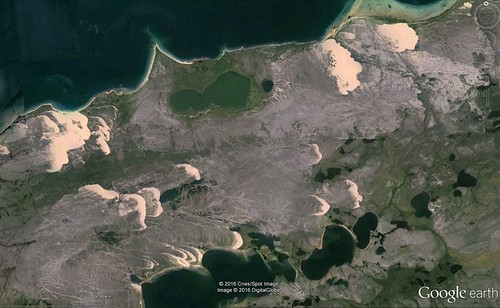
ReplyDeleteAthabasca Sand Dunes.
About the geological significance I'm not very sure but this is what Wikipedia says:
"he Athabasca Sand Dunes are estimated to be approximately 8,000 years old, formed near the end of the Last glacial period. As glaciers receded, meltwater washed enormous quantities of sand, silt and sediment from local sandstone into Lake Athabasca, whose water level was at the time much higher than currently. As the lake level declined to its modern depth, the large sand deposits were revealed. The sand dunes are quite unstable, being constantly shifted by winds, which push the dunes at the edges of the area into the surrounding forest. Evidence also suggests that fires have greatly influenced the winds shaping the dunes. Unlike the dunes closer to the lake, the southern dunes are in fact quite stable relative to other areas in the region.
Common desert geological features can be found in the region, such as eskers, desert pavement, and beach ridges. In addition, portions of the Williams River in the region flow through braided channels in the sand.
The dunes are generally parabolic in shape. The sand almost completely covers the underlying sandstone deposits; the bedrock is around 20 metres below ground on average. The entire sandy region, including areas south of the dunes, serves as an enormous aquifer, which as a result significantly affects plant life and dune development."
Sorry, forgot to add the location: Saskatchewan, Canada.
ReplyDelete59° 8'22.75"N 108°35'28.24"W
Your turn... as usual for a contest of mine recently.
DeleteService returned... ;-)
DeleteNext WoGE #545 at:
ReplyDeletehttp://wogepaulvoestermans.blogspot.nl/2016/03/where-on-google-earth-545-in-woge-544.html