Sunday 29 May 2016

Where On Google Earth #572

Little did I know that I would be opening up a can of worms with the fact that I was able to find the location for Ole's 571 but was not really able to identify the geology that Ole was looking for with his additional comment "...what I am after happend when it IS bad."

This link from the Milford Lodge has enough geology for me as a non-geologist. This other site from http://www.fergusmurraysculpture.com has more.

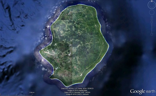
Contest #572:


As always, the first person to post the position and whatever is interesting about the geology/hydrology/geowhatever in this location, wins the privilege of hosting the next WoGE.

Previous WoGEs are collected by Felix on his blog and a KML file.

No Schott rule for this contest.

Saturday 14 May 2016

Where On Google Earth #568

Something about Felix's image for contest 567 struck me as familiar, probably after searching long and hard through deserts across the southwestern US for previous contests, and it was not long before I came across Blackhawk Landslide, off the northside of the San Bernardino Mountains, just east of LA. Location: 34.41N 116.79W.

From a thesis on the geology and mechanics of the slide at http://thesis.library.caltech.edu/691/" is this explanation.

Blackhawk Mountain, a resistant mass of marble thrust northward over uncemented sandstone and weathered gneiss, rises above southeastern Lucerne Valley at the eastern end of the rugged 4000-foot escarpment that separates the San Bernardino Mountains on the south from the Mojave Desert on the north. Spread out on the alluvial apron at the foot of the mountain is the Blackhawk rockslide, a lobe of nearly monolithologic marble breccia 30 to 100 feet thick, 2 miles wide, and nearly 5 miles long. At least two earlier similar but smaller rockslides have occurred in the area.

The rocks of the area comprise late Tertiary and Quaternary fanglomerates and breccias derived mainly from the gneiss, quartzite, Carboniferous marble, and Cretaceous quartz-monzonite of the San Bernardino Mountains. Uplift of Blackhawk Mountain occurred in two stages after deposition of the older fanglomerates and breccias: the first by over-thrusting from the south, and the second by monoclinal folding along a northwest-trending axis.

Geological evidence in the area shows that the Blackhawk rockslide traversed the gently inclined alluvial slope as a nearly nondeforming sheet of breccia moving more than 50 miles per hour. The hypothesis that compressed air, rather than water or mud, constituted the lubricating layer on which the breccia sheet slid qualitatively explains all of the principal physical features of the slide lobe. Theoretical analysis of the flow in the lubricating air layer indicates the quantitative feasibility of the air-lubrication hypothesis for the Blackhawk slide.

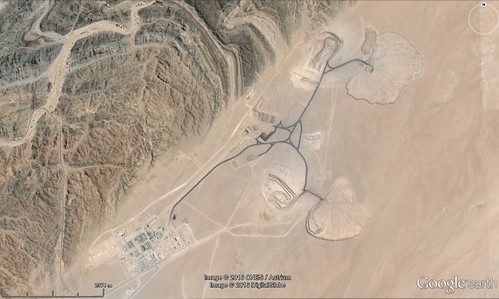
Contest #568:


Rules, tips and previous WoGEs are collected by Felix on his http://woge-felix.blogspot.ca/ blog with a KML file available with all WoGEs.
Tuesday 3 May 2016

Where on Google Earth #563

Elisabeth gave us a really tough contest with her 562 - I searched long and hard over northern latitudes looking for fault lines and straight valleys.

In the end, the hint led me to an island in my own country: Cape Breton Island. http://www.pc.gc.ca/eng/pn-np/ns/cbreton/natcul/natcul1/a/iii.aspx has the following information on this interesting geological feature.

The most spectacular fault in Cape Breton National Park is the Aspy Fault which extends 40 kilometres from the centre of the highlands to the ocean. Before the Atlantic Ocean formed, it may even have connected to faults in Europe like Scotland's Great Glen Fault, home to Loch Ness.

Streams in the park cut down into the plateau, forming deep V-shaped canyons. Running water naturally follows depressions in the land, so several rivers in the park follow fault lines. The eroding action of the water as well as the presence of the fault combine to form very deep canyons. The Aspy River flows down the Aspy Fault line in a very dramatic canyon which can be seen from the Cabot Trail.


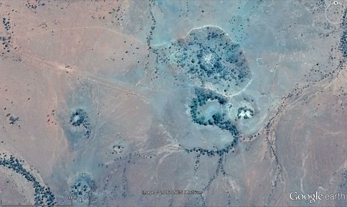
Contest #563 - hint: it's an island.


Rules, tips and previous WoGEs are collected by Felix on his http://woge-felix.blogspot.ca/ blog with a KML file available with all WoGEs.

The Schott rule applies for this contest (1 hour for every previous win) - published at 19.35 UTC, May 3rd, 2016