Monday 25 April 2016

Where on Google Earth #561

Elisabeth was kind to us with contest 558, but after several previous contests looking for volcanic activity of many kinds, my eye went straight to Iceland, where I was able to track the exact location down.

Once again, the hard part was identifying the geological feature... the Dieldartunguvhev hot spring in the centre of the image - for more information about this spot, go to this link: Deildartunguhver thermal spring

Contest #561:


Rules, tips and previous WoGEs are collected by Felix on his http://woge-felix.blogspot.ca/ blog with a KML file available with all WoGEs.

I will invoke the Schott rule again: one hour delay for each previous win.

Published at 1625 UTC, April 25, 2016

Sunday 24 April 2016

Where on Google Earth #559

Elisabeth gave us a real challenge with contest 558, based on the number of days it remained unsolved by players in the game - as well as how much of the world I had to search trying to find the correct combination of water and rock colours. I was not able to figure out the geological feature and had to resort to scanning GE for hours.

In the end, it was the northern part of Antelope Island, located in the south east corner of Great Salt Lake, Utah. The website for the state park located on the island mentions this for the geology:

Geology is the foundation for Antelope Island, and reveals a long history of complex geologic processes. Rocks on the island range from the oldest to the youngest in the state of Utah. Five periods of geologic time are preserved in detail. Unconformities are due to the area being elevated above sea level wherein rocks were either never deposited or were eroded away. Little is known of the geologic events represented by the older unconformities. The geology controls the collection and distribution of ground water and the location and size of springs.

Contest #559:


Rules, tips and previous WoGEs are collected by Felix on his http://woge-felix.blogspot.ca/ blog with a KML file available with all WoGEs.

The Schott rule applies for this contest (1 hour for every previous win)

Posted at 0015 UTC April 24, 2016.

Friday 15 April 2016

Where on Google Earth #556

The last contest from Ole (http://overburdenblog.blogspot.ca/2016/04/where-on-google-earth-555.html) was very hard for me as a non-geologist. I was able to pick out the "small" sinkholes, but Google searching took me to Guatemala, Japan and many other parts of the world that did not help. The flatness of the image did not help! Ole's hint helped a bit as it directed me towards something that had a special entrance, which turned out to be an underground river.

Luck intervened and I happened upon the Yucatan as a area of the world where there were underground rivers, and the sinkholes were "doors" into them.

Here is contest #556:


Click here for a bigger image.

Thursday 7 April 2016

Where On Google Earth #554

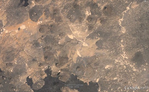
Paul presented us with a challenge that after the past few locations said Arizona, Utah or Nevada in the southwest USA. A quick search of northern Arizona lead me to Vermillion Cliffs National Monument, and to be more specific, the White Pocket area.

I supplied a link to an explanation of the geology in the area in contest #553. The information is repeated below.

http://www.amusingplanet.com/2013/03/white-pocket-vermilion-cliffs-national.html tells us that the entire area is covered in a gray rocky layer, sometimes only a few centimeters thick, above the red sandstone where the formations heave and drip that makes the entire landscape look like as if it was covered with icing sugar. In some spots the stone layers are completely twisted, just like an enormous marble cake.

The extraordinary geology at White Pocket is not easily explained. Some geologist proclaim that White Pocket is a result of “soft sediment deformation”, meaning the contortions and twisting and turning at White Pocket occurred back in Jurassic time while the sand was saturated and before the sand was completely turned into rock.

According to one retired petroleum geologist Marc Deshowitz, who studied White Pocket more than anyone else, believes the landscape was the result of a huge sand-slide mass, triggered by an earthquake, detaching from a tall dune and traveling rapidly downslope. As the mass slid and tumbled downslope, it ripped up chunks of laminated sand beneath that intermixed with the basal part of the slide. The sand mass eventually filled a large pond or oasis. This large sand mass is the featureless bleached-white sandstone or "cauliflower rock" seen today. The instantaneous loading from the sand mass caused pressure adjustments within the underlying saturated sand resulting in contortions and fluid escape structures such as sand volcanoes. Marc has identified at least 25 of these features supporting his theory.

Contest #554:


Click here for a larger image.